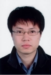


邢 诚讲师 邢诚,男,黑龙江哈尔滨人,研究生学历, 工学博士,武汉大学测绘学院测量工程研究所讲师。 研究方向:变形监测、工业测量、工程测量 办公电话:027-68758480 电子邮件:chxing@sgg.whu.edu.cn 办公地点:武汉大学信息学部测绘学院405 通讯地址:湖北省武汉市,洪山区珞喻路129 号,武汉大学测绘学院
一、教育经历
2001.09-2005.06 武汉大学测绘学院,测绘工程专业,本科,工学学士
2005.09-2011.06 武汉大学测绘学院,大地测量学与测量工程专业,研究生(硕博连读),工学博士
2009.09-2010.09 澳大利亚新南威尔士大学测量与空间信息系统学院,联合培养博士
二、工作经历
2011.07- 武汉大学测绘学院测量工程研究所,讲师
三、论文及论著
1. Cheng Xing, Jian-qiang Wang. An Improved Method for Circle Detection.International Conference on Intelligent Robotics and Applications, 2008.
2. Cheng Xing, Jingjing Huang. AnImproved Mosaic Method Based on SIFT Algorithm for UAV Sequence Images.International Conference on Computer Design and Applications.
3. Cheng Xing, Jinling Wang, Yaming Xu. Overlap Analysis of the Images from Unmanned Aerial ehicles. The 1st International Conference on Electrical and Control Engineering.
4. Cheng Xing, Jinling Wang, Yaming Xu. Arobust method for mosaicking sequence images obtained from UAV. The 2nd International Conference on Information Engineering and Computer Science. EI
检索
5. Cheng Xing, Jinling Wang, Yaming Xu. A Method for Building a Mosaic with UAV Images. International Journal of Information Engineering and Electronic Business.
6. Peng Wang, Xiao Zhou, Cheng Xing. Research on Ground-based SAR Interferometry Principles and Its Applications of Building Structure Displacement Monitoring. The 2nd International Conference on Electric Technology and Civil Engineering.
7. 徐亚明,邢诚. 一种基于拼接线的无人机序列影像拼接方法. 武汉大学学报(信息科学版).
8. 邢诚. 基于简化SIFT 算法的无人机影像重叠度分析. 哈尔滨工程大学学报.
9. 周校,王鹏,邢诚. 基于GB-SAR 的建筑物微变形测量研究. 测绘信息与工程.
10. 邢诚,刘冠兰. 一种改进的序列图像激光线提取方法. 测绘科学.
11. 邢诚,刘冠兰. 像素工厂的研究与探讨. 计算机与数字工程.
12. 邢诚,王建强等. 引入模型误差的非线性回归模型. 海洋测绘.
13. 邢诚,王建强等. 多种数值积分方法比较分析. 城市勘测.
14. 邢诚,沈琦等. 一种基于随机Hough 变换的椭圆检测方法. 计算机与数字工程.
15. Jian-qiang Wang, Cheng Xing. Application of Iterative Calculation of Matrix for Solving Ill-posed Problems. 2008 International Symposium on Computational Intelligence and Design (ISCID 2008).
16. 徐亚明,邢诚等. 几种激光光斑中心检测方法的比较. 海洋测绘.
17. 李红艳,陈治亚,邢诚等. 铁路既有线曲线复测计算方法 中国铁道科学.
18. 刘宗泉,贾志强,邢诚等. GPS 网WGS-84 平差坐标向地方独立坐标的转换.测绘信息与工程.
19. 徐亚明,刘冠兰,邢诚. 基于边缘检测的小波阈值图像去噪. 海洋测绘.
Curriculum Vitae
1. Personal details
Name: Xing Cheng
Address: School of Geodesy and Geomatics,
Wuhan University,
Wuhan, 430079,
P. R. China
Tel: 027-68758480
Fax: 027-68778371
Mobile: +86 13871533532
E-mail: chxing@sgg.whu.edu.cn
Web: www.sgg.whu.edu.cn
2. Education Experience
2005.09~2011.06 PH. D., Geodesy and Survey Engineering, School of
Geodesy and Geomatics, Wuhan University.
2009.09~2010.09 Joint training, School of Surveying and Spatial Information
Systems, University of New South Wales
2001.09~2005.06 B. SC., Surveying and Mapping, School of Geodesy and
Geomatics, Wuhan University.
3. Work Experience
2011.07~ Lecturer, Institute of Surveying Engineering, School of Geodesy
and Geomatics, Wuhan University.
4. Research Interests
Deformation monitoring, Industry surveying, Engineering survey
5. Publications
1. Cheng Xing, Jian-qiang Wang. An Improved Method for Circle Detection.
International Conference on Intelligent Robotics and Applications, 2008.
2. Cheng Xing, Jingjing Huang. An Improved Mosaic Method Based on SIFT
Algorithm for UAV Sequence Images. International Conference on Computer
Design and Applications.
3. Cheng Xing, Jinling Wang, Yaming Xu. Overlap Analysis of the Images from
Unmanned Aerial Vehicles. The 1st International Conference on Electrical and
Control Engineering.
4. Cheng Xing, Jinling Wang, Yaming Xu. A robust method for mosaicking
sequence images obtained from UAV. The 2nd International Conference on
Information Engineering and Computer Science. EI 检索
5. Cheng Xing, Jinling Wang, Yaming Xu. A Method for Building a Mosaic with
UAV Images. International Journal of Information Engineering and Electronic
Business.
6. Peng Wang, Xiao Zhou, Cheng Xing. Research on Ground-based SAR
Interferometry Principles and Its Applications of Building Structure
Displacement Monitoring. The 2nd International Conference on Electric
Technology and Civil Engineering.
7. Xu Yaming, Xing Cheng. A Mosaicking Method for UAV Sequence Images
Based on Seam Line. Geomatics and Information Science of Wuhan University.
8. Xing Cheng. Overlapping degree analysis of the images from unmanned aerial
vehicle based on a reduced SIFT algorithm. Journal of Harbin Engineering
University.
9. Zhou Xiao, Wang Peng, Xing Cheng. Rearch On Micro Deformation
Mearsurement Of Building Based On GB-SAR. 测绘信息与工程.
10. Xing Cheng, Liu Guanlan. An improved extraction method of laser beam in the
sequential images. Science of Surveying and Mapping.
11. Xing Cheng, Liu Guanlan. Study on the Pixel Factory. Computer & Digital
Engineering.
12. Xing Cheng, Wang Jianqiang. The Nonlinear Regression Model Introduced by
Model Error. Hydrographic Surveying and Charting.
13. Xing Cheng, Wang Jianqiang. Comparison and Analysis of Some Numerical
Integration Methods. Urban Geotechnical Investigation & Surveying.
14. Xing Cheng, Shen Qi. A Method for Ellipse Detection Using Randomized Hough
Transform. Computer & Digital Engineering.
15. Jian-qiang Wang, Cheng Xing. Application of Iterative Calculation of Matrix for
Solving Ill-posed Problems. 2008 International Symposium on Computational
Intelligence and Design (ISCID 2008).
16. Xu Yaming, Xing Cheng. Comparisons of Several Methods of Laser Spot Center
Detection. Hydrographic Surveying and Charting.
17. Li Hongyan, Chen Zhiya, Xingcheng. Calculation Method for Curve
Re-Surveying of the Existing Railway Line. China Railway Science.
18. Liu Zongquan, Jia Zhiqiang, Xing Cheng. TRANSFORMATION OF WGS-84
ADJUSTED COORDINATES OF GPS CONTROL NETWORK INTO LOCAL
INDEPENDENT COORDINATE SYSTEM. Journal of Geomatics.
19. Xu Yaming, Liu Guanlan, Xing Cheng. De-noising by Wavelet Transform Based
on Edge Detection. Hydrographic Surveying and Charting.